Where the techniques of Maths
are explained in simple terms.
Measurement - Time - Comparing locations on Earth's surface.
Test Yourself 1.
- Algebra & Number
- Calculus
- Financial Maths
- Functions & Quadratics
- Geometry
- Measurement
- Networks & Graphs
- Probability & Statistics
- Trigonometry
- Maths & beyond
- Index
| Comparing latitude or longitude. | 1. 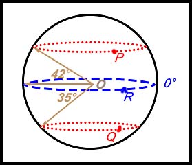 |
In the diagram at the left, O is the centre of Earth.
(i) Write down the latitudes of the points P, Q and R. (ii) What can be noted about the longitude of point P? Answer.(i) P is 42° N, Q is 35° S andR is 0° (the equator). (ii) nothing can be concluded about the longitude of P. |
| 2. Location A has coordinates (42° N, 24° W). Location B has coordinates (36° S and 116° E).
What are the coordinates of Location C which is half way between locations A and B? Answer.C is at (3° N, 46° E). |
||
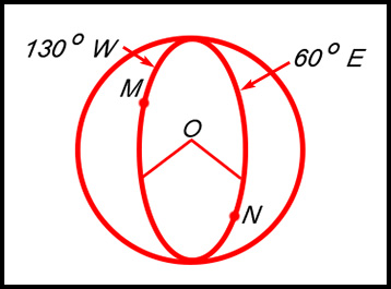
| 3. Which of the 4 statements at the right is true about points M and N on this diagram?
|
(a) The difference in longitude is 70o. (b) The difference in latitude is 70o. (c) The difference in longitude is 190o. (d) The difference in latitude is 190o. Answer.(c). |
|
| 4. An Australian mining company is mining for Rare Earth minerals at Hall's Creek in Western Australia (18.23° S, 127.67° W) and at La Paz, Arizona (33.9° N, 113.9° W). Which of these two locations is: Answer.(i) Hall's Creek. (ii) La Paz. |
||
| 5. Determine the angular difference in latitude between Ceduna in South Australia (32° S, 133° E) and Mumbai in India (19° N, 73° E). Answer.Latitude difference is 32° + 19° = 51°. |
||
| Finding coordinates. | 6. City A is located at (35°N, 125° E).
City B is located 60° to the east and 40° to the south of City A. What is the latitude and longitude of City B. Answer.5° S and 175° W. |
|
7. (i) Use Google to determine the location (in terms of degrees and minutes) for each of the following towns in Queensland:
(ii) Rank each of the 4 towns in terms of their position from west to east (ii) Rank each of the 4 towns in terms of their position from north to south. Answer.West to East: Aligator Creek, Dingo Beach, Moura, Banana.North to South: Aligator Creek, Dingo Beach, Banana, Moura. |
||
| 8. | ||
.